


An initial geophysical survey may identify several areas of archaeological interest, but the results don’t always reveal exactly what those features are or how they relate to the surrounding site. Some anomalies may suggest buried structures, while others remain unclear and require further investigation. Stage 4 builds on these findings by focusing on particular areas where additional information could help answer outstanding questions. Rather than immediately excavating, targeted non-intrusive investigation allows us to examine selected features more closely, compare evidence and develop a clearer understanding of what may lie beneath the surface. This helps reduce uncertainty and ensures that any further archaeological investigation is guided by the evidence already collected.
At this stage, the focus shifts from surveying the wider site to answering specific archaeological questions. This may involve more detailed surveys of selected areas, comparing different sources of evidence or using alternative techniques to investigate features identified earlier.
Following the initial geophysical survey, some areas of a site may require closer investigation. These could include potential buried structures, unclear anomalies or features that need further interpretation. Rather than surveying the entire site again, targeted investigation focuses on specific locations where additional information could help answer outstanding archaeological questions.
For example, if a wider geophysical survey identifies what may be buried foundations, a more detailed GPR survey could help investigate their extent and arrangement, where site conditions are suitable. Similarly, if the initial findings are unclear, a different survey technique may provide additional evidence to help explain what has been detected.
By comparing these results with historic maps, existing survey information and visible features on the ground, archaeologists can develop a clearer understanding of the areas being investigated. The aim is to establish what additional information is needed, where to investigate further and how the findings can guide the next stage of archaeological work.
Once an area has been selected for closer investigation, the next step is to examine what the original findings might represent. For example, a linear anomaly could indicate a buried wall, a former boundary or a natural variation in the ground. More detailed investigation may help establish whether the feature continues, changes direction or relates to other potential archaeological remains.
The additional findings can then be compared with the original geophysical survey results. Where different datasets support the same interpretation, confidence in the findings may increase. However, where results differ, this can highlight uncertainties that require further investigation.
By examining the evidence together, archaeologists can develop a clearer understanding of particular features and identify which questions remain unanswered. This helps ensure that any further investigation is focused on gathering information that will be genuinely useful.
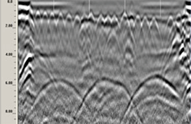
Ground Penetrating Radar (GPR) survey data showing subsurface reflections that may require further investigation and interpretation.
Not every archaeological feature produces a clear geophysical response. Some areas may show little evidence of buried remains, while others contain anomalies that are difficult to interpret. However, this does not necessarily mean that archaeology is absent.
In these situations, archaeologists can review the findings alongside historic mapping, existing site records and other survey information to decide whether further investigation would be useful. This may help identify areas where additional non-intrusive investigation could clarify the results, as well as locations that may require archaeological evaluation at a later stage.
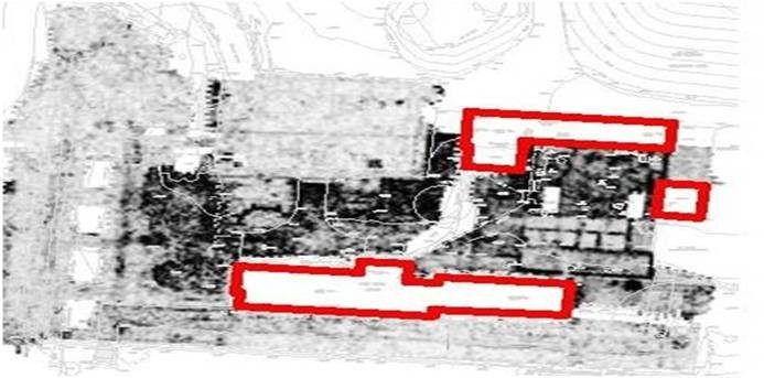
Geophysical survey interpretation plan highlighting areas in red where survey coverage was not possible, demonstrating gaps in the available survey information.
Stage 4 helps us move from identifying possible archaeological features to developing a clearer understanding of particular areas of interest. By examining selected features in more detail and comparing new findings with existing evidence, we can identify where uncertainty remains and whether further investigation is needed.
These findings help inform Stage 5 – Intrusive Archaeological Investigation, where archaeologists can use the evidence gathered to plan more targeted excavation and investigate specific questions. The aim is not to replace excavation, but to ensure that any ground disturbance is carefully considered, focused and supported by the available evidence.
Comments Off on Heritage & Archaeology – Stage 4: Refining the Picture