


Archaeology presents a unique challenge: investigating a site can sometimes destroy the very evidence we are trying to understand. While excavation is essential, it is also inherently destructive. Geophysical survey offers a way to investigate potential archaeological remains without disturbing the ground.
Building on the historical research from Stage 1 and the accurate site records established in Stage 2, geophysics helps us explore what may be hidden beneath the surface.
Geophysical survey measures variations in the physical properties of the ground, which can sometimes indicate buried archaeological features. Different techniques respond to different ground conditions and materials, meaning no single geophysical method is suitable for every archaeological site. Selecting the right technique depends on the site’s conditions, the potential archaeology and the information required.

Geophysical survey being carried out at a historic site to investigate potential buried archaeological features without excavation.
Geophysical surveys allow archaeologists to investigate large areas without excavation, helping identify patterns that may indicate buried remains. Different survey techniques can detect different types of features, from historic ditches and pits to foundations and other buried structures. By identifying areas of potential archaeological interest, geophysics can help guide further investigation and reduce unnecessary disturbance to sensitive heritage sites.
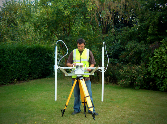
Geophysical survey equipment being used to investigate potential archaeological features beneath the surface.
Different geophysical techniques can help identify different types of archaeological features. Choosing the most suitable method depends on the site’s ground conditions, the type of archaeology expected and the information required.
Magnetic gradiometry measures variations in the Earth’s magnetic field and is particularly effective for identifying archaeological features such as ditches, pits, kilns, hearths and areas of burning. This technique can rapidly investigate large areas, helping archaeologists identify potential buried remains and understand patterns across a site.
Ground Penetrating Radar (GPR) uses electromagnetic waves to investigate what lies beneath the surface, helping identify potential buried archaeological features without excavation. It is particularly valuable for locating walls, foundations, floors, voids and other structural remains that may survive underground. GPR can provide information about the location and approximate depth of buried features, helping archaeologists better understand their arrangement beneath the surface. By analysing survey data at different depths, it may also be possible to identify changes in the layout of buried structures.

Ground Penetrating Radar (GPR) survey data from St Peter’s Church, showing subsurface reflections that may indicate buried archaeological features.
Earth resistance survey measures variations in the electrical resistance of the ground. For example, soil moisture and buried materials can affect these measurements. These variations can help identify archaeological features such as buried walls, foundations and ditches. Other techniques, including electromagnetic survey and electrical resistivity imaging, may also be appropriate depending on the archaeological and geological conditions of the site.
One of the main advantages of geophysical surveying is its ability to investigate large areas without excavation. Rather than relying entirely on individual trenches, geophysical surveys can reveal patterns across a wider site. Groups of anomalies may indicate buried enclosures, while linear responses could suggest former field boundaries or trackways. Concentrations of anomalies may also highlight areas of settlement or industrial activity. These findings help archaeologists build a clearer picture of how a site may have developed and been used over time.
Although geophysical surveys provide valuable information, they do not create a perfect picture of what lies beneath the ground. An anomaly is not automatically evidence of archaeology. Natural geology, ground conditions, modern disturbance and surface materials can all influence survey results. In addition, the size, depth and physical properties of archaeological remains affect how easily geophysical surveys can detect them. For this reason, archaeologists must carefully interpret geophysical findings alongside historical research, topographical survey data and other archaeological evidence.
Geophysics works best as part of a wider, phased archaeological investigation. The desk-based assessment establishes the historical context, while baseline mapping and heritage recording provide accurate information about the existing site. Geophysical survey adds another layer of evidence, helping identify potential buried features and areas that may require further investigation. By combining these findings, we can develop a clearer understanding of the site, reduce uncertainty and make more informed decisions about the next steps. This leads into Stage 4 – Targeted Non-Intrusive Investigation, where the evidence gathered so far can help focus further investigation on specific areas of archaeological interest, while minimising unnecessary disturbance to sensitive heritage sites.
Comments Off on Heritage & Archaeology – Stage 3: Looking Beneath the Surface with Geophysics