


Ground Penetrating Radar
Services:
Key facts:
To use a GPR system legally in the E.U operators should hold a license and follow an approved code of practice. Met are fully licensed by OFCOM and are members of EuroGPR, the pan Euro-pean trade association for users and manufacturers of GPR systems. (EuroGPR – http://www.eurogpr.org)
Ground Penetrating Radar (GPR) is one of the most versatile of geophysical techniques. It has become a standard technique for utility mapping, but also has extensive applications in hazard location, archaeology and engineering geology. Ground penetrating radar (GPR) is one of the most useful geophysical techniques due to its wide array of applications. It is easy to deploy, and systems are available, or can be designed, to access the most inconvenient of spaces or locations.
Although easy to use, the results can be hard to interpret, and easy to get wrong. Various site conditions exist which can render GPR ineffective, an experienced and responsible operator will always inform you in advance if techniques are likely to be compromised by site conditions. Dense clay soils or saline conditions are two such instances which can compromise a survey—the presence of reinforced concrete can also cause problems if the target is buried beneath the reinforcement.
GPR works by transmitting an electromagnetic pulse of energy into the ground. This pulse travels through different materials at different speeds, and when it meets a material with different physical properties some of the energy gets reflected back to the surface. By measuring the time taken for the pulse to travel to the target and back, and knowing the material that the pulse is travelling through, an estimate can be made as to the depth of the target. Typical Values for a damp, sandy soil (depths obtained may be shallower than this in practice due to clay content or other factors.)
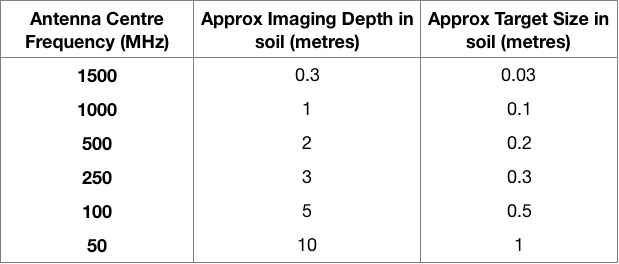
How deep a GPR system can ‘see’ is dependent upon the frequency of the antenna used, as is the size of the target that can be found. High frequency antennas are able to identify small features measuring just centimetres across, but are only able to penetrate a few metres at most. Lower frequency antennas can penetrate deeper but are only able to resolve larger targets (see table).
The amount of energy reflected depends on the contrast between the material properties. Contrasts between materials such as air and water, or soil and metal are large, and therefore give bigger reflections, and so features such as large voids or buried metallic objects make good targets.
GPR surveys are usually carried out by pushing the instrument along a straight line and recording the data. This produces a profile which is a vertical slice into the ground. Specialist software can be used to process the data and interpret the results. By surveying many such profiles closely spaced together, and usually in two directions, a three-dimensional model of the sub-surface can be obtained. Timeslice images can then be generated that show an area in plan at a certain depth below the ground.
A GPR survey can also be carried out in scanning mode—where data is not recorded and features are marked up on the ground as they are identified in real time. Although these types of survey are usually cheaper due to the reduced time spent in the office, caution needs to be exercised as they are highly dependent upon the skill and experience of the operator. Even in the hands of an experienced geophysicist, detection rates of features are usually lower in a scanning survey than in a detailed survey.
Applications
GPR is widely used in utility mapping because of its ability to locate plastic pipes, but it also has a host of other applications. It is useful as the same data can be interrogated for lots of different purposes. For example, a detailed survey can be carried out to locate utility services and any other below ground hazards, such as voiding, buried fuel tanks/drums or in-situ foundations. It can also be used to combine a utility survey with an archaeological survey or similar. This may re-quire use of different antennas to provide different levels of depth penetration, but carrying out the surveys together usually results in cost savings.
GPR surveys are useful to carry out as a complement to a magnetic or conductivity survey for buried features, as GPR can provide more detailed information on the depth of anomalies. A combination of electromagnetic techniques and GPR is often used for brownfield reconnaissance or to characterise an unknown area prior to intrusive site investigations. They can also be effective techniques for locating mine shafts and remains of mineworkings.
High frequency GPR surveys are used to investigate pavement and road construction; identify structural defects or carry out concrete evaluations such as estimating the thickness of ground slabs or mapping out rebar within the slab. Surveying roads can be done using specialist antennas that are vehicle mounted, allowing data to be collected at traffic speeds and reducing the need for traffic management measures, road closures and disruption to the general public.
Geological and environmental applications include bedrock profiling, mapping quaternary sediments, location of landfill deposits and monitoring changes over time. GPR can be used to map out features such as badger setts, rabbit warrens, or tree root systems providing a non-intrusive solution with minimum disturbance.
Met Consultancy Group (Met) employs qualified geophysicists to specify and carry out all GPR surveys, so you can be confident that survey execution, data processing and interpretation is being carried out by competent people. Contact us to discuss any project or application that you may have and we will be able to advise on the most suitable survey approach, and whether GPR is the best tool for the job.